KIS-ORCA subsea cables#
IMPORTANT: There may be some incorrect name assignments as a simple backfill and multiline conversion was used and no further checks were done
import os
import subprocess
from zipfile import BadZipFile, ZipFile

import contextily as cx
import geopandas as gpd
import matplotlib.pyplot as plt
import pandas as pd

from h2ss import data as rd
# base data download directory
DATA_DIR = os.path.join("data", "subsea-cables")

FILE_NAME = "Olex_KIS-ORCA-v2023.zip"

URL = f"https://kis-orca.org/wp-content/uploads/2020/12/{FILE_NAME}"

DATA_FILE = os.path.join(DATA_DIR, FILE_NAME)

# basemap cache directory
cx.set_cache_dir(os.path.join("data", "basemaps"))
plt.rcParams["xtick.major.size"] = 0
plt.rcParams["ytick.major.size"] = 0
rd.download_data(url=URL, data_dir=DATA_DIR, file_name=FILE_NAME)
Data 'Olex_KIS-ORCA-v2023.zip' already exists in 'data/subsea-cables'.
Data downloaded on: 2023-11-12 22:35:48.040165+00:00
Download URL: https://kis-orca.org/wp-content/uploads/2020/12/Olex_KIS-ORCA-v2023.zip
SHA256 hash: fd646e524a74fc36ee9401a0f1af6e977464ae76c6d8cc0126f4c738c6e4480a
Read data#
# extract the archive
try:
    z = ZipFile(DATA_FILE)
    z.extractall(DATA_DIR)
except BadZipFile:
    print("There were issues with the file", DATA_FILE)
DATA_FILE = os.path.join(DATA_DIR, ZipFile(DATA_FILE).namelist()[0])
# extract gz file using gzip
# https://www.gnu.org/software/gzip/
subprocess.run(["gzip", "-d", "<", DATA_FILE, ">", DATA_FILE[:-3]])
0
DATA_FILE = DATA_FILE[:-3]
for n, line in enumerate(open(DATA_FILE, "r", encoding="ISO-8859-15")):
    if n < 11:
        print(line[:-1])
'"20230130_KIS-ORCAv2023_31-Jan-2023"
Rute uten navn
Fikspos
3052.58800 -291.95800 1675123200 Gulramme
Navn Repeater
MTekst 0:Issue  : "20230130_KIS-ORCAv2023_31-Jan-2023"
MTekst 1:Object : Repeater
MTekst 2:Detail : APOLLO NORTH
MTekst 3:Contact: VODAFONE
MTekst 4:Status : ACTIVE
MTekst 5:Tel    : +44(0)207 138 7117
# coordinates
with open(f"{DATA_FILE}_data.txt", "w", encoding="utf-8") as outfile:
    for n, line in enumerate(open(DATA_FILE, "r", encoding="ISO-8859-15")):
        if line[0].isdigit():
            outfile.write(f"{n} {line}")

# names
with open(f"{DATA_FILE}_names.txt", "w", encoding="utf-8") as outfile:
    for n, line in enumerate(open(DATA_FILE, "r", encoding="ISO-8859-15")):
        if "MTekst 2" in str(line):
            outfile.write(f"{n}, {line[18:]}")
data = pd.read_csv(
    f"{DATA_FILE}_data.txt",
    header=None,
    sep=" ",
    names=["y", "x", "z", "text"],
)

names = pd.read_csv(
    f"{DATA_FILE}_names.txt", header=None, names=["index", "name"]
)
data.head()
| y | x | z | text | |
|---|---|---|---|---|
| 3 | 3052.588 | -291.958 | 1675123200 | Gulramme |
| 14 | 3059.834 | -325.624 | 1675123200 | Gulramme |
| 25 | 3060.112 | -361.904 | 1675123200 | Gulramme |
| 36 | 3060.160 | -404.239 | 1675123200 | Gulramme |
| 47 | 3059.491 | -424.326 | 1675123200 | Gulramme |
data.shape
(442011, 4)
names.head()
| index | name | |
|---|---|---|
| 0 | 7 | APOLLO NORTH |
| 1 | 18 | APOLLO NORTH |
| 2 | 29 | APOLLO NORTH |
| 3 | 40 | APOLLO NORTH |
| 4 | 51 | APOLLO NORTH |
names.shape
(21647, 2)
names.set_index("index", inplace=True)
Merge names with coordinates#
names = names.reindex(range(max(data.index) + 1))
# handle missing data with backfill / forward fill
names = names.bfill()
names = names.ffill()
names.head()
| name | |
|---|---|
| index | |
| 0 | APOLLO NORTH |
| 1 | APOLLO NORTH |
| 2 | APOLLO NORTH |
| 3 | APOLLO NORTH |
| 4 | APOLLO NORTH |
names.shape
(657317, 1)
# merge names and data
data = pd.merge(data, names, left_index=True, right_index=True)
data.head()
| y | x | z | text | name | |
|---|---|---|---|---|---|
| 3 | 3052.588 | -291.958 | 1675123200 | Gulramme | APOLLO NORTH |
| 14 | 3059.834 | -325.624 | 1675123200 | Gulramme | APOLLO NORTH |
| 25 | 3060.112 | -361.904 | 1675123200 | Gulramme | APOLLO NORTH |
| 36 | 3060.160 | -404.239 | 1675123200 | Gulramme | APOLLO NORTH |
| 47 | 3059.491 | -424.326 | 1675123200 | Gulramme | APOLLO NORTH |
data.shape
(442011, 5)
Convert to geodataframe#
# drop duplicate entries using coordinates
data = data.drop_duplicates(["y", "x"])
data.shape
(419079, 5)
# convert coords from minutes to degrees
# https://gis.stackexchange.com/a/241922
data["x"] = data["x"] / 60
data["y"] = data["y"] / 60
data.head()
| y | x | z | text | name | |
|---|---|---|---|---|---|
| 3 | 50.876467 | -4.865967 | 1675123200 | Gulramme | APOLLO NORTH |
| 14 | 50.997233 | -5.427067 | 1675123200 | Gulramme | APOLLO NORTH |
| 25 | 51.001867 | -6.031733 | 1675123200 | Gulramme | APOLLO NORTH |
| 36 | 51.002667 | -6.737317 | 1675123200 | Gulramme | APOLLO NORTH |
| 47 | 50.991517 | -7.072100 | 1675123200 | Gulramme | APOLLO NORTH |
# convert to geodataframe
data = gpd.GeoDataFrame(
    data, geometry=gpd.points_from_xy(data.x, data.y, crs=4326)
)
data.head()
| y | x | z | text | name | geometry | |
|---|---|---|---|---|---|---|
| 3 | 50.876467 | -4.865967 | 1675123200 | Gulramme | APOLLO NORTH | POINT (-4.86597 50.87647) |
| 14 | 50.997233 | -5.427067 | 1675123200 | Gulramme | APOLLO NORTH | POINT (-5.42707 50.99723) |
| 25 | 51.001867 | -6.031733 | 1675123200 | Gulramme | APOLLO NORTH | POINT (-6.03173 51.00187) |
| 36 | 51.002667 | -6.737317 | 1675123200 | Gulramme | APOLLO NORTH | POINT (-6.73732 51.00267) |
| 47 | 50.991517 | -7.072100 | 1675123200 | Gulramme | APOLLO NORTH | POINT (-7.07210 50.99152) |
data.crs
<Geographic 2D CRS: EPSG:4326>
Name: WGS 84
Axis Info [ellipsoidal]:
- Lat[north]: Geodetic latitude (degree)
- Lon[east]: Geodetic longitude (degree)
Area of Use:
- name: World.
- bounds: (-180.0, -90.0, 180.0, 90.0)
Datum: World Geodetic System 1984 ensemble
- Ellipsoid: WGS 84
- Prime Meridian: Greenwich
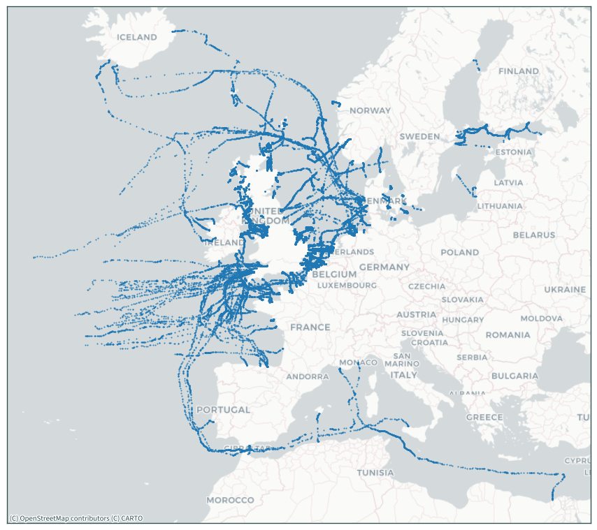
ax = data.to_crs(3857).plot(marker=".", markersize=1, figsize=(9, 9))
cx.add_basemap(ax, source=cx.providers.CartoDB.Positron)
plt.tick_params(labelbottom=False, labelleft=False)
plt.tight_layout()
plt.show()
Dissolve geometries#
# dissolve by name
data = data.dissolve("name").reset_index()
data.head()
| name | geometry | y | x | z | text | |
|---|---|---|---|---|---|---|
| 0 | 50m Fishing Advisory Safety Zone ABERDEEN WIN... | MULTIPOINT (-2.06615 57.21560, -2.06615 57.215... | 57.215867 | -2.063850 | 1675123200 | Brunsirkel |
| 1 | 50m Fishing Advisory Safety Zone ANHOLT WIND ... | MULTIPOINT (-1.98668 57.21603, -1.98667 57.216... | 57.216033 | -1.986683 | 1675123200 | Brunsirkel |
| 2 | 50m Fishing Advisory Safety Zone BARROW WIND ... | MULTIPOINT (-3.32998 53.99517, -3.32998 53.995... | 56.676350 | 11.160500 | 1675123200 | Brunsirkel |
| 3 | 50m Fishing Advisory Safety Zone BEATRICE WIN... | MULTIPOINT (-3.29142 53.98413, -3.29140 53.984... | 53.984133 | -3.291417 | 1675123200 | Brunsirkel |
| 4 | 50m Fishing Advisory Safety Zone BLYTH DEMO P... | MULTIPOINT (-2.89668 58.25688, -2.89668 58.256... | 58.256883 | -2.896683 | 1675123200 | Brunsirkel |
data.shape
(6126, 6)
Data for the Irish Sea#
# extent
mask = (-7, 53, -4.5, 54)
data_ie = data.clip(mask)
data_ie
| name | geometry | y | x | z | text | |
|---|---|---|---|---|---|---|
| 2139 | HIBERNIA ATLANTIC SEG.D TELECOM CABLE | MULTIPOINT (-6.12517 53.39633, -6.12417 53.397... | 53.402833 | -6.104000 | 1675123200 | Brunsirkel |
| 902 | CELTIC TELECOM CABLE | MULTIPOINT (-5.03608 53.37180, -5.03058 53.36447) | 53.371800 | -5.036083 | 1675123200 | Brunsirkel |
| 1295 | ESAT 2 TELECOM CABLE | MULTIPOINT (-6.20643 53.32382, -6.20222 53.324... | 50.088667 | -5.710950 | 1675123200 | Brunsirkel |
| 2135 | HIBERNIA ATLANTIC | MULTIPOINT (-6.01117 53.43167, -5.97792 53.347... | 53.893500 | -4.318000 | 1675123200 | Rødramme |
| 4794 | ROCKABILL TELECOM CABLE | MULTIPOINT (-6.10937 53.49357, -6.10557 53.493... | 51.423183 | 1.616950 | 1675123200 | Brunsirkel |
| 6113 | WESTERN LINK ARDNEILL TO WIRRAL 1 POWER CABLE | MULTIPOINT (-5.10547 53.94238, -5.10395 53.939... | 51.085450 | 1.220567 | 1675123200 | Brunsirkel |
| 1288 | EMERALD BRIDGE | POINT (-4.95258 53.28408) | 53.284083 | -4.952583 | 1675123200 | Rødramme |
| 1294 | ESAT 2 | MULTIPOINT (-6.04087 53.34388, -6.02700 53.34995) | 53.343883 | -6.040867 | 1675123200 | Rødramme |
| 5019 | SIRIUS SOUTH | MULTIPOINT (-5.96933 53.47467, -5.64117 53.556... | 53.731500 | -3.591333 | 1675123200 | Rødramme |
| 2137 | HIBERNIA ATLANTIC SEG.A TELECOM CABLE | MULTIPOINT (-5.07918 53.95348, -5.07802 53.948... | 51.740550 | 1.289317 | 1675123200 | Brunsirkel |
| 2120 | HAVHINGSTEN SEG 1.5 TELECOM CABLE | MULTIPOINT (-4.57660 53.84340, -4.57633 53.841... | 53.932983 | -4.566550 | 1675123200 | Brunsirkel |
| 3119 | LANIS 1 TELECOM CABLE | MULTIPOINT (-6.12443 53.43257, -6.12413 53.432... | 53.447933 | -6.072367 | 1675123200 | Brunsirkel |
| 2118 | HAVHINGSTEN SEG 1.3 TELECOM CABLE | MULTIPOINT (-5.00462 53.84620, -4.98688 53.851... | 53.920800 | -4.971600 | 1675123200 | Brunsirkel |
| 85 | AE CONNECT SEG 05 TELECOM CABLE | MULTIPOINT (-4.70408 53.24558, -4.69628 53.247... | 53.245583 | -4.704083 | 1675123200 | Brunsirkel |
| 2119 | HAVHINGSTEN SEG 1.4 TELECOM CABLE | MULTIPOINT (-4.99742 53.84620, -4.99542 53.847... | 53.847283 | -4.950200 | 1675123200 | Brunsirkel |
| 2117 | HAVHINGSTEN SEG 1.2 TELECOM CABLE | MULTIPOINT (-4.96995 53.92820, -4.95973 53.961... | 54.084900 | -4.760417 | 1675123200 | Brunsirkel |
| 1289 | EMERALD BRIDGE TELECOM CABLE | MULTIPOINT (-6.11635 53.43230, -6.05838 53.442... | 52.377817 | 4.528117 | 1675123200 | Brunsirkel |
| 1017 | DOGGER BANK A WF EXTENT | POINT (-6.12470 53.43220) | 53.432200 | -6.124700 | 1675123200 | Brunsirkel |
| 2121 | HAVHINGSTEN SEG 2.1 TELECOM CABLE | POINT (-4.57918 53.84250) | 53.842500 | -4.579183 | 1675123200 | Brunsirkel |
| 2138 | HIBERNIA ATLANTIC SEG.C TELECOM CABLE | MULTIPOINT (-6.07333 53.41667, -6.06650 53.419... | 55.375967 | -6.554117 | 1675123200 | Brunsirkel |
| 5020 | SIRIUS SOUTH TELECOM CABLE | MULTIPOINT (-6.05768 53.45273, -6.00000 53.466... | 55.582000 | -4.838000 | 1675123200 | Brunsirkel |
| 751 | BT-TE1 TELECOM CABLE | MULTIPOINT (-6.12460 53.43145, -6.03127 53.454... | 56.737583 | -5.241533 | 1675123200 | Brunsirkel |
| 1281 | EAST WEST INTERCONNECTOR POWER CABLE | MULTIPOINT (-6.08452 53.52402, -6.08442 53.523... | 58.186050 | -2.745967 | 1675123200 | Brunsirkel |
| 903 | CELTIXCONNECT TELECOM CABLE | MULTIPOINT (-6.17010 53.35503, -6.16405 53.352... | 55.836833 | 8.125800 | 1675123200 | Brunsirkel |
| 2107 | HAVFRUE SEG 07 TELECOM CABLE | MULTIPOINT (-6.08127 53.54735, -6.08102 53.545... | 53.549400 | -6.036033 | 1675123200 | Brunsirkel |
| 2116 | HAVHINGSTEN SEG 1.1 TELECOM CABLE | MULTIPOINT (-6.01972 53.55267, -5.97415 53.558... | 55.126600 | -1.111167 | 1675123200 | Brunsirkel |
data_ie.shape
(26, 6)
Convert multipoint geometries to multilines#
# convert all multi points to multi lines
data_ie_1 = data_ie[
    data_ie["geometry"].astype(str).str.contains("MULTI")
].reset_index(drop=True)

data_ie_1["geometry"] = gpd.GeoSeries.from_wkt(
    "LINESTRING ("
    + data_ie_1["geometry"].astype(str).str.split("(", expand=True)[1],
    crs=4326,
)
# merge multilines with remaining geometry data
data_ie = pd.concat(
    [
        data_ie[~data_ie["geometry"].astype(str).str.contains("MULTI")],
        data_ie_1,
    ]
).reset_index(drop=True)
data_ie
| name | geometry | y | x | z | text | |
|---|---|---|---|---|---|---|
| 0 | EMERALD BRIDGE | POINT (-4.95258 53.28408) | 53.284083 | -4.952583 | 1675123200 | Rødramme |
| 1 | DOGGER BANK A WF EXTENT | POINT (-6.12470 53.43220) | 53.432200 | -6.124700 | 1675123200 | Brunsirkel |
| 2 | HAVHINGSTEN SEG 2.1 TELECOM CABLE | POINT (-4.57918 53.84250) | 53.842500 | -4.579183 | 1675123200 | Brunsirkel |
| 3 | HIBERNIA ATLANTIC SEG.D TELECOM CABLE | LINESTRING (-6.12517 53.39633, -6.12417 53.397... | 53.402833 | -6.104000 | 1675123200 | Brunsirkel |
| 4 | CELTIC TELECOM CABLE | LINESTRING (-5.03608 53.37180, -5.03058 53.36447) | 53.371800 | -5.036083 | 1675123200 | Brunsirkel |
| 5 | ESAT 2 TELECOM CABLE | LINESTRING (-6.20643 53.32382, -6.20222 53.324... | 50.088667 | -5.710950 | 1675123200 | Brunsirkel |
| 6 | HIBERNIA ATLANTIC | LINESTRING (-6.01117 53.43167, -5.97792 53.347... | 53.893500 | -4.318000 | 1675123200 | Rødramme |
| 7 | ROCKABILL TELECOM CABLE | LINESTRING (-6.10937 53.49357, -6.10557 53.493... | 51.423183 | 1.616950 | 1675123200 | Brunsirkel |
| 8 | WESTERN LINK ARDNEILL TO WIRRAL 1 POWER CABLE | LINESTRING (-5.10547 53.94238, -5.10395 53.939... | 51.085450 | 1.220567 | 1675123200 | Brunsirkel |
| 9 | ESAT 2 | LINESTRING (-6.04087 53.34388, -6.02700 53.34995) | 53.343883 | -6.040867 | 1675123200 | Rødramme |
| 10 | SIRIUS SOUTH | LINESTRING (-5.96933 53.47467, -5.64117 53.556... | 53.731500 | -3.591333 | 1675123200 | Rødramme |
| 11 | HIBERNIA ATLANTIC SEG.A TELECOM CABLE | LINESTRING (-5.07918 53.95348, -5.07802 53.948... | 51.740550 | 1.289317 | 1675123200 | Brunsirkel |
| 12 | HAVHINGSTEN SEG 1.5 TELECOM CABLE | LINESTRING (-4.57660 53.84340, -4.57633 53.841... | 53.932983 | -4.566550 | 1675123200 | Brunsirkel |
| 13 | LANIS 1 TELECOM CABLE | LINESTRING (-6.12443 53.43257, -6.12413 53.432... | 53.447933 | -6.072367 | 1675123200 | Brunsirkel |
| 14 | HAVHINGSTEN SEG 1.3 TELECOM CABLE | LINESTRING (-5.00462 53.84620, -4.98688 53.851... | 53.920800 | -4.971600 | 1675123200 | Brunsirkel |
| 15 | AE CONNECT SEG 05 TELECOM CABLE | LINESTRING (-4.70408 53.24558, -4.69628 53.247... | 53.245583 | -4.704083 | 1675123200 | Brunsirkel |
| 16 | HAVHINGSTEN SEG 1.4 TELECOM CABLE | LINESTRING (-4.99742 53.84620, -4.99542 53.847... | 53.847283 | -4.950200 | 1675123200 | Brunsirkel |
| 17 | HAVHINGSTEN SEG 1.2 TELECOM CABLE | LINESTRING (-4.96995 53.92820, -4.95973 53.961... | 54.084900 | -4.760417 | 1675123200 | Brunsirkel |
| 18 | EMERALD BRIDGE TELECOM CABLE | LINESTRING (-6.11635 53.43230, -6.05838 53.442... | 52.377817 | 4.528117 | 1675123200 | Brunsirkel |
| 19 | HIBERNIA ATLANTIC SEG.C TELECOM CABLE | LINESTRING (-6.07333 53.41667, -6.06650 53.419... | 55.375967 | -6.554117 | 1675123200 | Brunsirkel |
| 20 | SIRIUS SOUTH TELECOM CABLE | LINESTRING (-6.05768 53.45273, -6.00000 53.466... | 55.582000 | -4.838000 | 1675123200 | Brunsirkel |
| 21 | BT-TE1 TELECOM CABLE | LINESTRING (-6.12460 53.43145, -6.03127 53.454... | 56.737583 | -5.241533 | 1675123200 | Brunsirkel |
| 22 | EAST WEST INTERCONNECTOR POWER CABLE | LINESTRING (-6.08452 53.52402, -6.08442 53.523... | 58.186050 | -2.745967 | 1675123200 | Brunsirkel |
| 23 | CELTIXCONNECT TELECOM CABLE | LINESTRING (-6.17010 53.35503, -6.16405 53.352... | 55.836833 | 8.125800 | 1675123200 | Brunsirkel |
| 24 | HAVFRUE SEG 07 TELECOM CABLE | LINESTRING (-6.08127 53.54735, -6.08102 53.545... | 53.549400 | -6.036033 | 1675123200 | Brunsirkel |
| 25 | HAVHINGSTEN SEG 1.1 TELECOM CABLE | LINESTRING (-6.01972 53.55267, -5.97415 53.558... | 55.126600 | -1.111167 | 1675123200 | Brunsirkel |
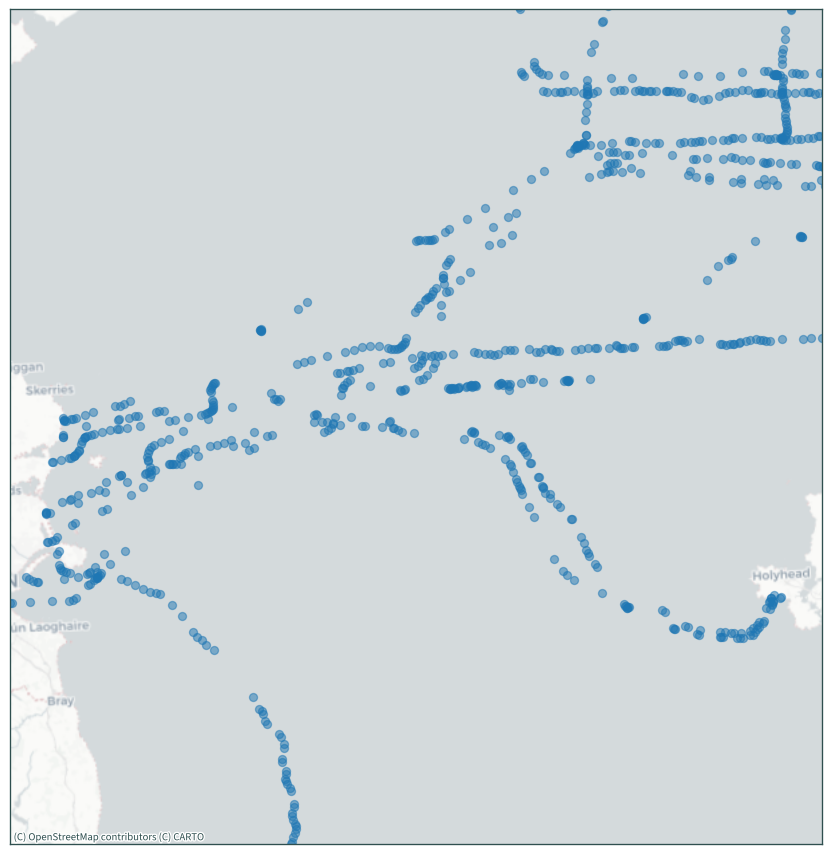
# get bounds of Irish Sea data
xmin, ymin, xmax, ymax = data_ie.to_crs(rd.CRS).total_bounds
# view plotter points in the Irish Sea
ax = data.to_crs(rd.CRS).plot(alpha=0.5, figsize=(9, 9))
plt.xlim(xmin, xmax)
plt.ylim(ymin, ymax)
cx.add_basemap(ax, source=cx.providers.CartoDB.Positron, crs=rd.CRS)
plt.tick_params(labelbottom=False, labelleft=False)
plt.tight_layout()
plt.show()
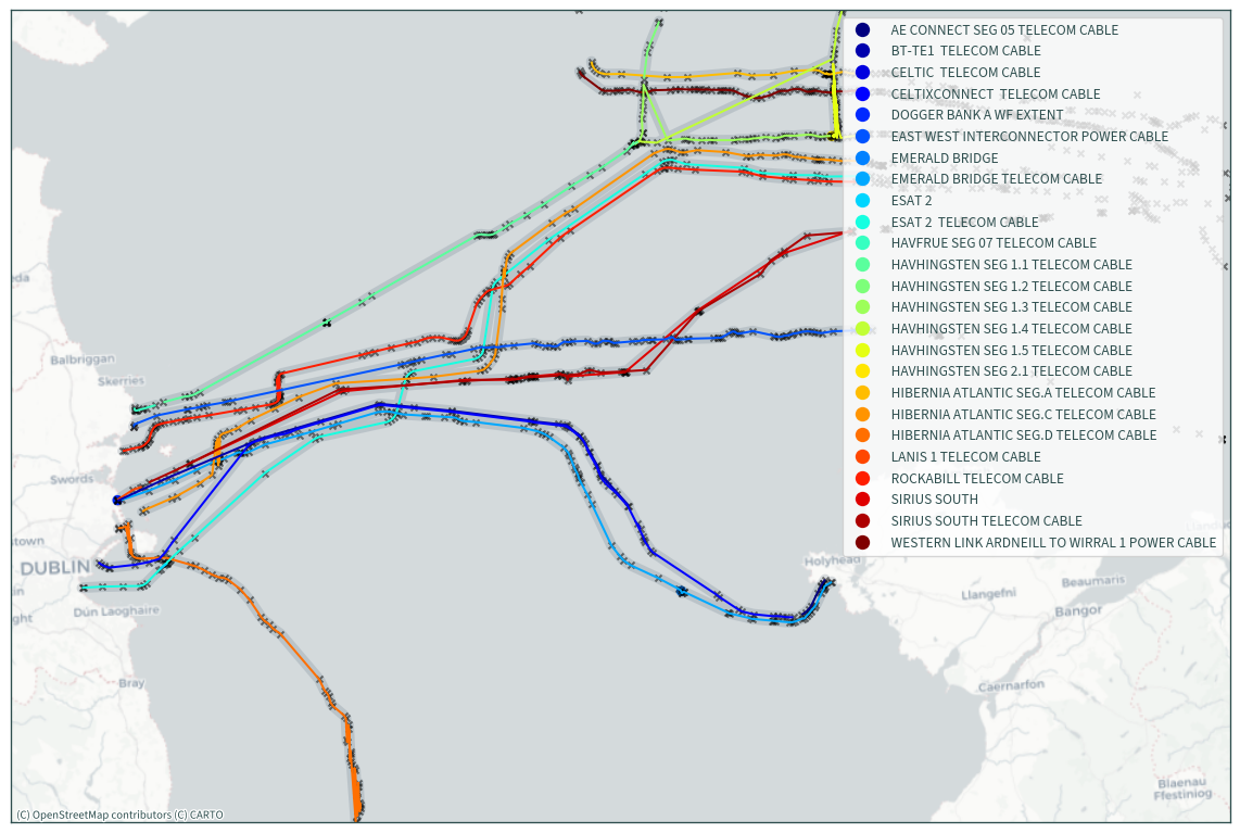
# remove incorrect data lines that are obvious - Hibernia Atlantic
data_ie = data_ie.drop([6]).reset_index(drop=True)
ax = (
    gpd.GeoDataFrame(geometry=data_ie.to_crs(rd.CRS).buffer(750))
    .dissolve()
    .plot(figsize=(12, 12), alpha=0.25, color="slategrey")
)
data_ie.to_crs(rd.CRS).plot(
    column="name",
    legend=True,
    ax=ax,
    cmap="jet",
    legend_kwds={"loc": "upper right"},
)
data.to_crs(rd.CRS).plot(
    ax=ax, marker="x", color="black", markersize=20, alpha=0.5
)
plt.xlim(xmin - 10000, xmax + 50000)
plt.ylim(ymin, ymax)
cx.add_basemap(ax, source=cx.providers.CartoDB.Positron, crs=rd.CRS)
plt.tick_params(labelbottom=False, labelleft=False)
plt.tight_layout()
plt.show()
data_ie.to_file(os.path.join(DATA_DIR, "KIS-ORCA.gpkg"))