Exploration wells#
https://data.marine.ie/geonetwork/srv/eng/catalog.search#/metadata/ie.marine.data:dataset.2171
https://data.gov.ie/dataset/exploration-wells-in-the-irish-offshore
import os
from zipfile import ZipFile

import contextily as cx
import matplotlib.pyplot as plt

from h2ss import data as rd
plt.rcParams["xtick.major.size"] = 0
plt.rcParams["ytick.major.size"] = 0
# base data download directory
DATA_DIR = os.path.join("data", "exploration-wells")

FILE_NAME = "Exploration_Wells_Irish_Offshore.shapezip.zip"

URL = f"https://atlas.marine.ie/midata/EnergyResourcesExploration/{FILE_NAME}"

DATA_FILE = os.path.join(DATA_DIR, FILE_NAME)

# basemap cache directory
cx.set_cache_dir(os.path.join("data", "basemaps"))
rd.download_data(url=URL, data_dir=DATA_DIR, file_name=FILE_NAME)
Data 'Exploration_Wells_Irish_Offshore.shapezip.zip' already exists in 'data/exploration-wells'.
Data downloaded on: 2023-09-15 12:56:05.840492+00:00
Download URL: https://atlas.marine.ie/midata/EnergyResourcesExploration/Exploration_Wells_Irish_Offshore.shapezip.zip
SHA256 hash: 9a40c29082e359932b238828fe94ec1334f4fc2b5ea643648e47eeb7aeaa8949
ZipFile(DATA_FILE).namelist()
['Exploration_Wells_Irish_Offshore.shapezip/',
 'Exploration_Wells_Irish_Offshore.shapezip/Exploration_Wells_Irish_Offshore.cpg',
 'Exploration_Wells_Irish_Offshore.shapezip/Exploration_Wells_Irish_Offshore.dbf',
 'Exploration_Wells_Irish_Offshore.shapezip/Exploration_Wells_Irish_Offshore.prj',
 'Exploration_Wells_Irish_Offshore.shapezip/Exploration_Wells_Irish_Offshore.sbn',
 'Exploration_Wells_Irish_Offshore.shapezip/Exploration_Wells_Irish_Offshore.sbx',
 'Exploration_Wells_Irish_Offshore.shapezip/Exploration_Wells_Irish_Offshore.shp',
 'Exploration_Wells_Irish_Offshore.shapezip/Exploration_Wells_Irish_Offshore.shp.xml',
 'Exploration_Wells_Irish_Offshore.shapezip/Exploration_Wells_Irish_Offshore.shx']
wells = rd.read_shapefile_from_zip(data_path=DATA_FILE)
wells.shape
(173, 19)
wells.head()
| OBJECTID | REF_NO_ | WELL_NO_ | SPUD_LATID | SPUD_LONGI | DDLATITUDE | DDLONGITUD | WELL_CLASS | AREA | OPERATOR | RIG_NAME | TD__MD_ | RIG_DATUM | WATER_DEPT | UNIT | SPUD_DATE | RIG_RELEAS | WELL_STATU | geometry | |
|---|---|---|---|---|---|---|---|---|---|---|---|---|---|---|---|---|---|---|---|
| 0 | 1 | 1 | 48/25-1 | 51° 18' 55.100" N | 08° 03' 19.900" W | 51.3153056 | -8.0555278 | Exploration | North Celtic Sea Basin | Marathon | Glomar North Sea | 10941 | 31 | 307 | ft | 1970-05-16 | 1971-02-25 | P & A with/without shows or untested pay | POINT (-8.05708 51.31434) |
| 1 | 2 | 2 | 50/11-1 | 51° 34' 55.300" N | 06° 57' 18.500" W | 51.5820278 | -6.9551389 | Exploration | North Celtic Sea Basin | Marathon | Glomar North Sea | 11906 | 31 | 236 | ft | 1971-02-27 | 1971-09-10 | P & A with/without shows or untested pay | POINT (-6.95668 51.58109) |
| 2 | 3 | 3 | 48/25-2 | 51° 19' 39.505" N | 08° 05' 48.595" W | 51.3276403 | -8.0968319 | Exploration | North Celtic Sea Basin | Marathon | Glomar North Sea | 6549 | 31 | 304 | ft | 1971-09-13 | 1971-11-09 | P & A Gas Well | POINT (-8.09839 51.32668) |
| 3 | 4 | 4 | 48/20-1A | 51° 21' 07.772" N | 08° 00' 21.764" W | 51.3521589 | -8.0060456 | Appraisal | North Celtic Sea Basin | Marathon | Glomar North Sea | 7101 | 31 | 295 | ft | 1972-05-06 | 1972-07-25 | P & A Gas Well | POINT (-8.00760 51.35120) |
| 4 | 5 | 5 | 58/3-1 | 50° 53' 46.693" N | 07° 35' 10.207" W | 50.8963036 | -7.5861686 | Exploration | South Celtic Sea Basin | Marathon | Glomar North Sea | 9379 | 31 | 330 | ft | 1972-07-31 | 1972-09-23 | P & A with/without shows or untested pay | POINT (-7.58770 50.89533) |
wells.crs
<Geographic 2D CRS: EPSG:4326>
Name: WGS 84
Axis Info [ellipsoidal]:
- Lat[north]: Geodetic latitude (degree)
- Lon[east]: Geodetic longitude (degree)
Area of Use:
- name: World.
- bounds: (-180.0, -90.0, 180.0, 90.0)
Datum: World Geodetic System 1984 ensemble
- Ellipsoid: WGS 84
- Prime Meridian: Greenwich
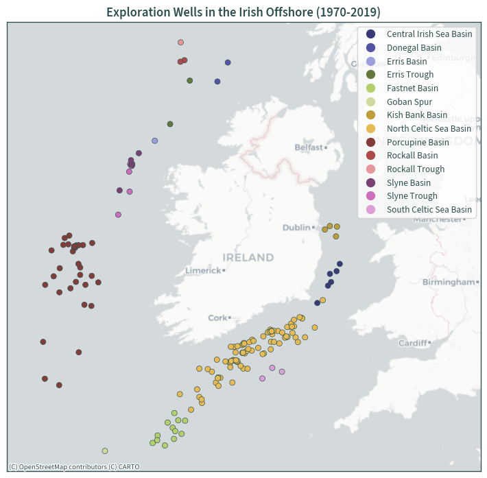
ax = wells.to_crs(3857).plot(
    column="AREA",
    legend=True,
    cmap="tab20b",
    figsize=(7.5, 7.5),
    legend_kwds={"loc": "upper right"},
    linewidth=0.5,
    edgecolor="darkslategrey",
)
plt.xlim(-1.6e6, -0.2e6)
cx.add_basemap(ax, source=cx.providers.CartoDB.Positron, zoom=6)

plt.title("Exploration Wells in the Irish Offshore (1970-2019)")

plt.tick_params(labelbottom=False, labelleft=False)
plt.tight_layout()
plt.show()